From the top of the plane, the appearance of the city of Palu is so alluring. The city lives on the edge of a sharply narrowed bay. From the north, the incoming sea water narrows into a bay, calculated using a digital map, the length of Palu Bay reaches approx 40 kilometer. The sea is dammed by nature. High valley stretches rise into natural walls to the right and left of the bay. At the end of the bay, The city of Palu supports itself as an administrative city that is becoming more and more lively every day.
Late afternoon, The high hills on either side of Palu Bay are calming. Thin fog covers the top of Bukit Barat and Bukit Timur, as if guarding the city of Palu firmly from the right and left sides. The hill that extends to the west has a peak height 2.200 meter (Mount Gawalise peak). Meanwhile, the hill to the east which is more gentle has a peak height 1.900 meter.
Even though Palu City is surrounded by attractive natural landscapes, but in the middle of the valley was hidden a long trail, from Palu City to the south, known as Fault (fault) Palu-Koro, one of the most active earthquake faults in the world.
Various geological studies and seismic analysis mention, The total length of the Palu Koro fault line is approx 500 km. This fault cuts Palu City almost perpendicularly from north to south. The Palu Koro Fault Line on land has a length of approx 250 km, divides the middle of Palu City, following the flow of the Palu River, all the way south through Kulawi District, Gimpu Village and Gintu Village in Sigi Regency, until ending in Bone Bay.
Pay attention to its very active seismic status, It could be said that the Palu Koro Fault brings exotic landscapes, but it also hides big concerns. Various historical records from decades ago record the impact of large earthquakes on scales above >7 the Richter scale was once a sad story. Stories that are retold passed down from generation to generation. The story about the earthquake that shook all the houses, causing houses to collapse.
There is even a story about a large earthquake which then triggered a large tidal wave, commonly known as a tsunami. Local residents along the Palu Koro Fault know him by name: 'Standing Sea Water'.
Traces of a large earthquake from the Palu-Koro Fault
For geology researchers, Sulawesi Island is a unique hidden landscape. Believe it or not, Scientific facts state that geological processes that are so complicated and complex over tens of millions of years have formed the island of Sulawesi to resemble the letter K. Several tens of millions of years ago, Sulawesi is just four floating islands. Then the island moved into one.
The four floating islands move at a rate of centimeters per year. Its movement is carried by three large plates, namely the Eurasian Plate, Indo-Australian Plate and Pacific Plate. Also influenced by the movement of the smaller Philippine plate from the Northeast direction.
The complexity and complexity of the tectonic process in the formation of Sulawesi Island is what ultimately led to the formation of faults that tore and crossed Sulawesi Island.. Current geological science knows that at least there are 9 The biggest fault that caused Sulawesi to be surrounded by earthquakes. These faults include the Palu Koro Fault, Poso Fault, Matano Fault, Lawanopo Fault, Cesar Walanae, Gorontalo Fault, Batui Fault, Cesar Tolo, and the Makassar Fault.
A Geologist from LIPI, Danny Hilman once said, The Palu Koro Fault and Matano Fault store large amounts of earthquake shock energy. "The earthquake propagation caused by the movement of the Palu Koro Fault and the Matano Fault is already at the highest level. Equivalent to gravitational acceleration 0,6 G. If you have 0,6 The G level is very serious,said Danny.
Reopening historical records of major earthquakes that occurred on Sulawesi Island, Many large earthquakes have been recorded as being caused by the movement of the Palu Koro Fault. For example, year 1828 ago, The Palu-Koro fault once shook Central Sulawesi and its surroundings with force 7,9 SR, At that time, the death toll was never recorded, However, folklore from generation to generation states that the number of victims was not small.
After the seismograph was discovered and the science of earthquakes began to develop, Earthquake records around the Palu-Koro fault are recorded in more detail. Appropriate 90 last year, or rather the date 1 December of the year 1927, in the middle of the sea west of the cities of Palu and Donggala, a big earthquake shook. The story of the local people of Palu remembers that at that time the sea water rose to a height of approximately 15 meter. "At that time, local people have said for generations, standing sea water,"said Abdullah, an earthquake researcher from the Department of Physics, Faculty of Mathematics and Natural Sciences, Tadulako University.
There were also records of large earthquakes in the year 1938 with the epicenter on land around Kulawi District. Palu Koro earthquake 1938 recorded by a seismograph on a shaking scale 7,9 scale judge. Then later 30 next year, on date 15 August of the year 1968 The Palu Koro fault again caused a large earthquake equivalent to 7,4 scale judge. The epicenter is in the West Coast region of Donggala Regency. Earthquake year 1968 again gave rise to a huge tsunami as high as 10 meter.
Historically, the closest earthquake recorded was the shock of the Palu Koro Fault in 1996 (7,9 scale judge), also in year 2012 yesterday with a scale 6,1 Richter scale with the epicenter near Lake Lindu, Sigi Regency.
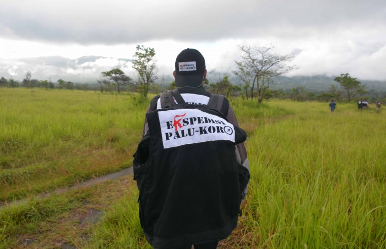
Palu-Koro Expedition: Explore the Palu-Koro Trail, Exploring Sulawesi from Various Sides
Even though it has a record of earthquakes that cannot be considered small, trigger a tsunami, it is even remembered in the local culture of the community for generations, but in reality the amount of research and documentation about Palu-Koro is minimal. Palu-Koro is not very well known by the public, Palu-Koro was only a small topic in house-to-house discussions, from coffee shop to coffee shop.
Even the current generation of Palu people, Palu-Koro is only known by name. “It's rare for people in Palu to understand more about Palu Koro. Most only understand stories passed down from generation to generation. About the history of earthquake movements, let alone knowing how to mitigate it, it is almost impossible to understand,"said Abdullah.
Starting from this effort, SKALA Association together with the Association of Indonesian Geologists (IAGI) Quick Response Action (ACT) collaborating to initiate a definite step with the title Palu-Koro Expedition. This cross-expertise collaboration was also initiated together with Planas PRB, and DisasterChannel.co.
“There is still very little documentation and research results about Palu-Koro, Even if there is, it's still very scientific. That's why we then had the idea to carry out the Palu-Koro expedition,’’ kata Trinirmalaningrum, SCALE director, an association engaged in research and campaigns for disaster reduction and sustainable development programs.
According to the timeline (timeline) which has been planned, The Palu-Koro Expedition, which is supported by various parties across expertise, will start in August this year 2017. But before carrying out the expedition in August, pre-expedition has started to roll out.
Third week of May 2017 Then the initial research team together with ACT flew to Palu to meet various parties to complete the initial data. This team is looking for important points to map the expedition's route, and chat with local residents living witnesses along the Palu Koro fault.
"The final data from this research will later be used by ACT and various related parties to develop strategic steps for disaster mitigation, reducing the impact of a possible large Palu Koro earthquake in the following years. A series of documentaries recording the Palu Koro Expedition will also be shown on private television and at commemorative events 90 the year the earthquake and 'standing sea water' occurred in the Palu Bay area 1 December 1927," said Insan Nurrahman, Vice President of Aksi Cepat Tunjungan.
Source: Shulhan Syamsur Rijal (ACT News)